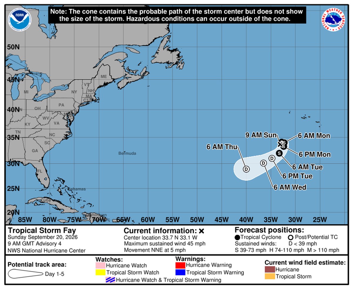
The National Hurricane Center named Tropical Storm Fay on Sunday morning, in the open Atlantic about 450 miles (730 km) southwest of the Azores. Its winds are 45 mph (75 km/h). And in the same advisory that gave it a name, the NHC listed no coastal watches or warnings anywhere, and put a single word under “hazards affecting land”: “None.”
The advisory — Public Advisory 4, issued 900 AM GMT Sunday, Sept. 20, 2026, headlined “…Depression Strengthens To Tropical Storm Fay…” — puts the center at 33.7N 33.1W. That position, at 33.1 degrees west, sits nearer the Azores than to any other land. Minimum central pressure is 1004 mb (29.65 inches). Fay is moving north-northeast at 5 mph (7 km/h). The advisory states: “A turn to the southwest is expected on Monday.” The storm is small. The Hurricane Center’s forecast discussion calls it “quite compact,” with its shower and thunderstorm activity confined to a band 100 to 150 nautical miles across, and tropical-storm-force winds reaching only 45 miles (75 km) from the center.
The forecast track has Fay gaining a little more strength over the next day — winds near 60 mph by Sunday evening — before it runs out of room to grow. The Hurricane Center’s discussion explains both halves of that: “The combination of relatively moist air and baroclinic enhancements from an approaching mid- to upper-level trough should cause Fay to gain some more strength during the next 12 to 24 hours. However, the trough is expected to lift out on Monday, and an increase in shear and intrusions of dry air should end the opportunity for strengthening and cause weakening by that time.” By the discussion’s own forecast table, Fay weakens through Monday and Tuesday, becomes a post-tropical remnant low Tuesday evening, and is marked “dissipated” by 6 a.m. GMT Friday, Sept. 25.
Portugal’s weather service, IPMA, has issued no warning for the Azores. All three of the archipelago’s warning zones show green on IPMA’s regional map, and the islands’ civil-protection service has issued no bulletin mentioning Fay; its most recent weather bulletin dates to Sept. 4. IPMA’s own forecast, as quoted by the Portuguese outlet Observador, says model guidance shows the storm “não deverá afetar diretamente o estado do tempo nos Açores” — in translation, that it should not directly affect Azores weather. Some localized rain and instability are still possible in the western and central island groups. The outlets we checked — the Associated Press and Fox Weather among them — framed it the same way: not a threat to land.
The more interesting number is the one behind Fay’s name. It is the sixth named storm of the 2026 Atlantic season — after Arthur, Bertha, Cristobal, Dolly and Edouard — and by the Hurricane Center’s own season archive, not one of the six has been a hurricane. That is ten days after Sept. 10, the date the NHC’s climatology page identifies as the season’s peak, when it says “most activity” occurs “between mid-August and mid-October.” The same page puts an average season, measured over 1991 to 2020, at 14 named storms and 7 hurricanes, and says “the first hurricane tends to form in early to mid-August.” This season has gone more than a month past that average date with none.
The Pacific side of the Hurricane Center’s watch is a mirror image. The same Sunday advisory cycle tracked Tropical Storm Odalys in the eastern Pacific — near 11.4N 124.5W, which NHC’s outlook places “over a thousand miles southwest of the southern tip of Baja California” — still at 40 mph and moving northwest at 8 mph, also with no coastal watches or warnings in effect. Odalys is not a hurricane yet; NHC forecasts it will reach hurricane strength by Monday. By NHC’s own list of this year’s eastern Pacific storms, that would make it the sixth hurricane of that season, and, counting every named storm on the list, the fifteenth. Closer to shore, NHC’s 5 a.m. PDT eastern Pacific Tropical Weather Outlook is tracking a separate, broader low-pressure system about 400 miles south of Manzanillo, Mexico. NHC says a tropical depression “is likely to form within the next day or so as the system moves generally northward off the coast of southwestern Mexico,” putting the formation chance at “high…90 percent” through both 48 hours and seven days, and adding that “Interests along the southwestern and west-central coast of Mexico should monitor the progress of this system.” One agency, two oceans, two very different seasons.
The Hurricane Center does not expect the Atlantic to produce anything else soon. Its 8 a.m. EDT Atlantic Tropical Weather Outlook, issued the same Sunday, Sept. 20, 2026, says plainly: “Tropical cyclone formation is not expected during the next 7 days.”
The Hurricane Center’s next complete advisory on Fay is due at 300 PM GMT (3 p.m. GMT) Sunday. Nothing in the current forecast changes the basic shape of the story: a storm that strengthens slightly, turns away from the islands nearest it, and is gone by the end of the week.
Sources and further reading
- Tropical Storm Fay Public Advisory Number 4 (AL062026)
- Tropical Storm Fay Forecast Discussion Number 4 (AL062026)
- Tropical cyclone climatology — season peak and 1991-2020 averages
- Tropical Storm Odalys Public Advisory (EP162026)
- NHC glossary — post-tropical cyclone, remnant low, watches and warnings
- Alertas — Azores regional civil protection