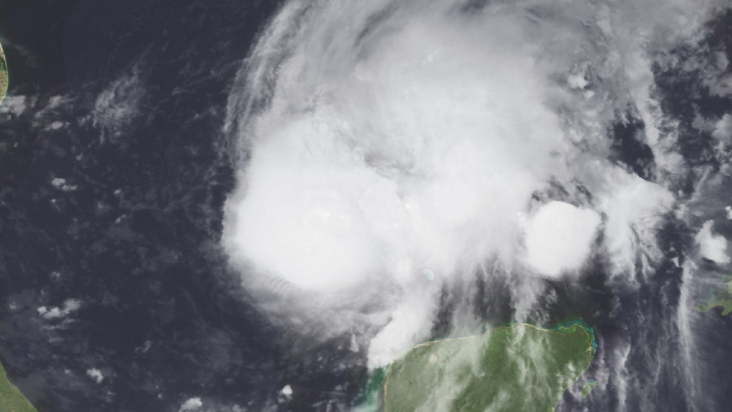
As of the National Hurricane Center’s 11 a.m. EDT (10 a.m. CDT) Advisory 8 on Thursday, Oct. 8, 2026, Hurricane Isaias has strengthened to maximum sustained winds of 85 mph. Storm surge warnings run from the mouth of the Mississippi River to Florida’s Suwannee River, and the hurricane warning runs from Ocean Springs, Mississippi, to the Bay/Gulf County line in Florida. The hurricane center expects landfall “late Friday or early Saturday.” Conditions can change with each update.
What the hurricane center is telling people to do today
The advisory says “preparations to protect life and property from storm surge and damaging winds in the warning area should be rushed to completion today.” Residents in the warning area “should follow advice given by local officials and evacuate immediately if told to do so.” Storm surge leads the hurricane center’s key messages as the life-threatening danger: “A life-threatening storm surge is expected from the Mouth of the Mississippi River to Suwannee, Florida.” Residents of the Hurricane Warning area in the Florida Panhandle, southern Alabama and southern Mississippi “should prepare for the possibility of long-duration power outages.”
Where Isaias is and where it is going
The hurricane center put the center of Isaias at 23.7 N, 90.2 W at 10 a.m. CDT. That is about 170 miles north of Progreso, Mexico, and about 380 miles south of the mouth of the Mississippi River. It was moving east-northeast at 10 mph, with a minimum central pressure of 975 millibars. The advisory’s headline was “ISAIAS STRONGER.” CBS News, on a page updated at 10:05 a.m. EDT, and NBC News, on a page published at 4:11 a.m. EDT, both report that Isaias is the first hurricane of the 2026 Atlantic season.
A sustained wind of 85 mph falls in the Category 1 range (74 to 95 mph) of the Saffir-Simpson scale. Fox Weather also describes Isaias as a Category 1 hurricane.
The hurricane center says a turn toward the northeast is expected later today, followed by a turn northward on Friday. Isaias is expected to pass north of the Yucatan Peninsula later today and “make landfall along the U.S. northern Gulf Coast within the warning area late Friday or early Saturday.”
Hurricane-force winds extend outward up to 15 miles from the center, and tropical-storm-force winds extend outward up to 90 miles. The hurricane center’s forecast expects that wind field to grow. Its forecast table has tropical-storm-force winds reaching out 150 nautical miles (about 170 miles) in the northeast quadrant at the 24-hour point, and 140 nautical miles (about 160 miles) at the 36-hour point. That is well beyond today’s 90 miles.
The hurricane center expects 1 to 3 inches of rain through Thursday across coastal portions of the eastern Bay of Campeche, with isolated higher amounts possible in Campeche and western Yucatan. It says gusty winds are possible in portions of the Yucatan Peninsula today.
What each warning means
The hurricane center lists four alerts in effect. It defines each one in the advisory.
- Storm Surge Warning, from the mouth of the Mississippi River to the Suwannee River in Florida. It “means there is a danger of life-threatening inundation, from rising water moving inland from the coastline, during the next 36 hours.” A new piece of this warning, from the Steinhatchee River to the Suwannee River, was added with this advisory.
- Hurricane Warning, from Ocean Springs, Mississippi, to the Bay/Gulf County line in Florida. It “means that hurricane conditions are expected somewhere within the warning area.” The advisory adds that a warning is “typically issued 36 hours before the anticipated first occurrence of tropical-storm-force winds, conditions that make outside preparations difficult or dangerous.” The hurricane center expects tropical storm conditions to begin Friday.
- Tropical Storm Warning, from the Jefferson/Plaquemines Parish line in Louisiana to west of Ocean Springs, and from east of the Bay/Gulf County line to the Aucilla River in Florida. It “means that tropical storm conditions are expected somewhere within the warning area within 36 hours.”
- Storm Surge Watch, from the Suwannee River to Yankeetown, Florida. It “means there is a possibility of life-threatening inundation” during the next 48 hours.
The Storm Surge Warning area is wider than the Hurricane Warning area.
How high the water could get
The hurricane center says the water could reach these heights above ground “somewhere in the indicated areas if the peak surge occurs at the time of high tide”:
- Ocean Springs, Mississippi, to Indian Pass, Florida: 5 to 7 feet
- Mobile Bay: 5 to 7 feet
- Indian Pass to the Steinhatchee River, Florida: 4 to 6 feet
- Mouth of the Mississippi River to Ocean Springs: 3 to 5 feet
- Steinhatchee River to the Suwannee River: 3 to 5 feet
- Suwannee River to Yankeetown: 2 to 4 feet
“The deepest water will occur along the immediate coast near and to the east of the landfall location,” the advisory says, where the surge “will be accompanied by large and dangerous waves.” It adds that surge flooding “can vary greatly over short distances,” so readers should check products from their local National Weather Service office.
Wind, rain, tornadoes and surf
Wind. Hurricane conditions are expected within the Hurricane Warning area Friday night into early Saturday. Tropical storm conditions begin on Friday. Key message 2 says damaging hurricane-force winds are expected over portions of the Florida Panhandle, southern Alabama and southern Mississippi where a Hurricane Warning is in effect.
Rain. From Friday through the weekend, the hurricane center expects 3 to 7 inches across the central Gulf Coast, from far southeastern Louisiana to the Florida Big Bend. Localized totals up to 15 inches are possible, “particularly within banding across the Florida Panhandle and Big Bend.” Much of the Southeast, as far north as the Tennessee Valley and the Carolinas, could see 1 to 3 inches, with localized amounts up to 5 inches.
The advisory says “considerable impacts” are possible across much of southern Alabama and the Florida Panhandle into southwestern Georgia, and that river flooding “some of which could be significant” is expected. CBS News gives its own figure of “as much as 10 inches in some places along the coast,” and Fox Weather quotes its Forecast Center as showing “6 to 10 inches with localized higher amounts.” The hurricane center’s advisory puts localized totals up to 15 inches.
Tornadoes. Isolated tornadoes are possible Friday night in coastal Alabama, the Florida Panhandle and far southwestern Georgia. The threat continues Saturday for eastern Alabama, Georgia and northern Florida.
Surf. Swells reach the western and northern portions of the Yucatan Peninsula later today and spread toward the Gulf Coast on Friday. The advisory says they “are likely to cause life-threatening surf and rip current conditions.”
Why the strength forecast is uncertain
The hurricane center’s Thursday discussion calls the intensity forecast up to landfall “somewhat challenging.” It gives two competing factors. The hurricane should cross waters of high ocean heat content and fairly moist air through Friday. But the SHIPS model input parameters “show a significant increase in vertical wind shear, particularly when [Isaias] nears the coast.”
A microwave satellite image “shows a closed ring around the eye,” which the forecasters call “typically a harbinger of rapid intensification.” But they add that “in view of the expected stronger shear in 24-36 hours, some decrease in intensity is indicated as Isaias approaches the coast.”
Air Force Hurricane Hunter aircraft found the pressure still falling, with winds near 75 knots (about 85 mph). More reconnaissance flights are scheduled today, tonight and Friday.
The hurricane center’s forecast table has winds of 105 mph at 0000 UTC Friday, which is 7 p.m. CDT (8 p.m. EDT) Thursday evening. Its forecast peaks at 110 mph at 1200 UTC Friday (7 a.m. CDT), then eases to 100 mph by 0000 UTC Saturday (7 p.m. CDT Friday).
On the Saffir-Simpson scale, 110 mph is the top of the Category 2 range (96 to 110 mph). The table never reaches 111 mph, the Category 3 threshold. Fox Weather, on a page updated at 10:47 a.m. EDT Thursday, says Isaias is forecast to hit “as a dangerous Category 2 hurricane,” while an analysis on the same page by its hurricane specialist Bryan Norcross says Isaias “could reach Category 3 strength.” The discussion says Isaias “is expected to remain a dangerous hurricane through landfall.” Fox Weather also says “uncertainty remains regarding exactly where and how strong Isaias will be” at landfall. The hurricane center states no category at landfall.
What has been announced so far
- Florida. CBS News, on a page updated at 10:05 a.m. EDT, reports that Gov. Ron DeSantis declared a state of emergency “for more than two dozen counties.” NBC News puts it at 25 counties in the Panhandle and Big Bend and says the state planned to deploy a Miami-based urban search and rescue task force.
- Okaloosa County, Florida. CBS reports mandatory evacuations in parts of the county, “set to take effect Thursday at 12 p.m. ET,” per CBS’s 10:05 a.m. EDT page. Fox Weather (10:47 a.m. EDT) reports evacuation orders for Zones A and B. NBC says some coastal areas.
- Alabama. CBS and NBC report that Gov. Kay Ivey issued a state of emergency for 40 counties. CBS says voluntary evacuations were in place for coastal spots in southeastern Alabama. Fox Weather (10:47 a.m. EDT) reports evacuation orders for the entire west end of Dauphin Island; its page does not say who issued them, and it gives the same lack of attribution for the Okaloosa zones.
- Gulf Shores and Orange Beach, Alabama. Per Fox Weather, the cities encouraged non-residents and residents in low-lying, flood-prone areas to leave voluntarily. NBC describes it as encouraging people in low-lying areas to evacuate voluntarily. CBS, speaking of Gulf Shores only, says officials urged non-residents to leave.
- Schools and utilities. NBC reports that at least four Florida school districts canceled classes for later in the week, and that electric utilities in Pensacola were pre-positioning crews.
- Oil. NBC reports that “Some Gulf oil wells paused production.” Citing what it calls the “Marine Minerals Administration,” it says about 25% of the region’s oil production was temporarily halted as of Wednesday, about 511,000 barrels a day, and that eight of the Gulf’s 371 manned oil platforms were evacuated.
- Mississippi and Louisiana. As of Fox Weather’s 1:21 a.m. EDT page, Mississippi Emergency Management was coordinating with first responders and the National Guard to deploy resources as requested. No Louisiana or Mississippi evacuation orders or state declarations appeared in the sources read as of the 11 a.m. EDT advisory. Readers there should check with their county emergency management office.
Inland effects
The hurricane center’s forecast has Isaias moving inland and weakening quickly after landfall. Its table has winds of 40 mph by 1200 UTC Saturday (7 a.m. CDT), when the center is forecast near 32.3 N, 87.8 W, inland. But the discussion says “gusty winds are expected well inland after landfall,” given the expected growth of the wind field and the storm’s faster forward speed.
Key message 3 says damaging wind gusts “are possible over much of central and northern Alabama and portions of western and northern Georgia, especially in areas of higher terrain.” It says additional Tropical Storm and High Wind Watches and Warnings “will likely be required” for portions of that area later today. The advice is to secure loose outdoor items, avoid driving high-profile vehicles and prepare for power outages.
What is not known yet
- The landfall point and strength. The hurricane center says only that landfall will come within the warning area, late Friday or early Saturday.
- Impacts. No damage, power-outage or casualty figures from the storm itself appeared in the sources read as of the 11 a.m. EDT advisory.
When the next update comes
The next intermediate advisory is due at 1 p.m. CDT (2 p.m. EDT), and the next complete advisory at 4 p.m. CDT (5 p.m. EDT). For information specific to a neighborhood, the hurricane center directs readers to their local National Weather Service forecast office.