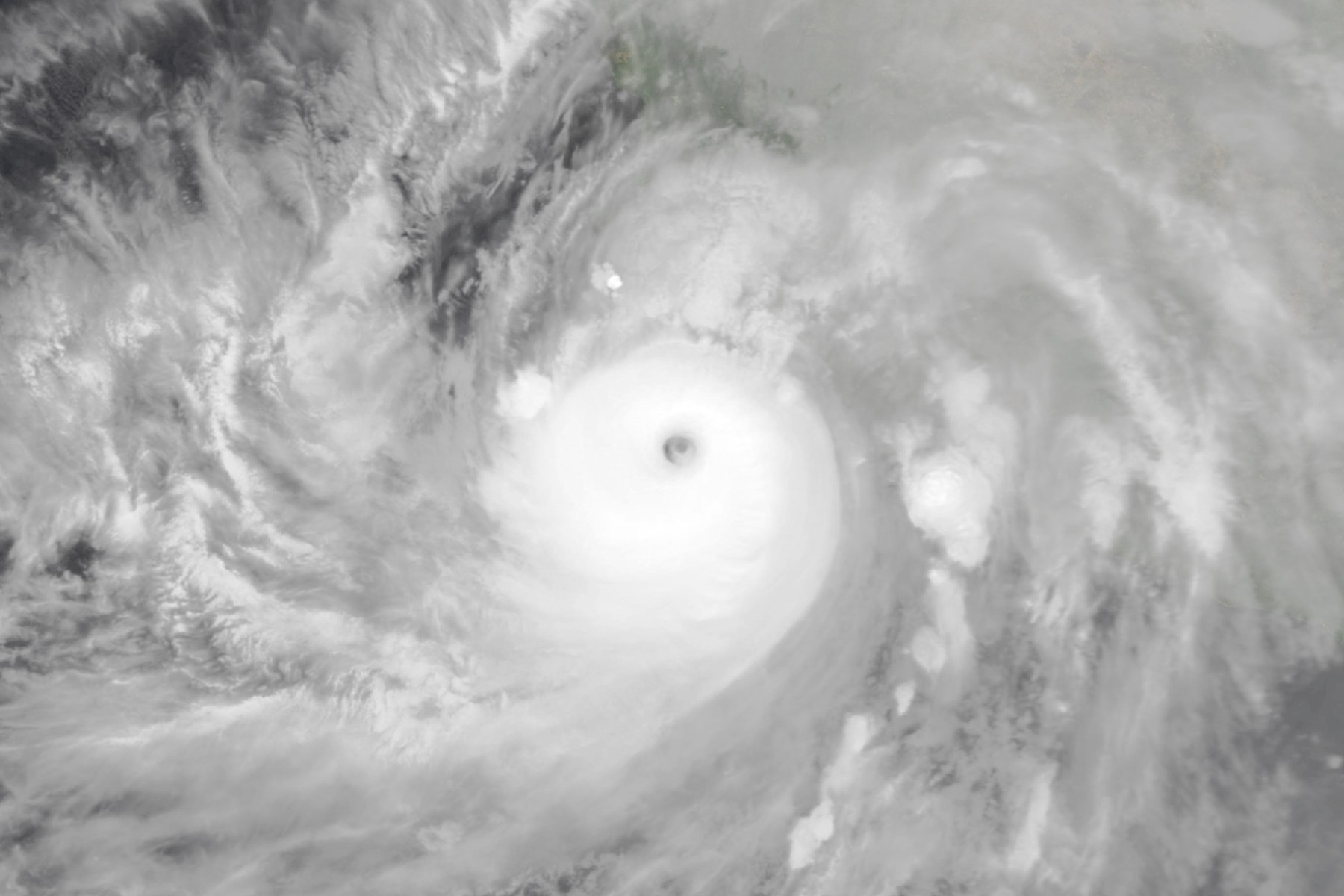
Update, Oct. 13, 2026: Simon is now a small Category 1 hurricane. The National Hurricane Center’s Advisory 26, issued at 2 p.m. MST Tuesday, Oct. 13, put it near 20.2 North, 107.5 West, about 115 miles west of Cabo Corrientes, with 90 mph winds and a pressure of 977 millibars, drifting west at 2 mph. Hurricane-force winds extend only about 10 miles from the center. The only watch in effect is a Hurricane Watch for Las Islas Marias; the government of Mexico discontinued the watches for mainland Mexico. Forecasters expect rainfall of 1 to 2 inches, with isolated totals of 3 inches, over parts of Baja California Sur, Nayarit and Sinaloa by Friday, and they expect Simon to stay a hurricane through Thursday, then turn north or north-northwest late in the week. Simon peaked at 155 mph (Category 4) with a pressure of 928 millibars on Saturday night and early Sunday, Oct. 10-11 (Advisories 15 and 15A), as its core came near the coast of west-central Mexico, and it weakened through Monday, Oct. 12. The rainfall totals of up to 30 inches described below were forecast when Simon was a stronger, closer storm; the sections below are the account written on Sunday night, Oct. 11.
Hurricane Simon, a Category 3 storm, was moving slowly northwest at 5 mph about 45 miles off Mexico’s Jalisco coast as of the National Hurricane Center’s 11 p.m. MST Sunday update, and a hurricane warning is in effect for part of the west-central coast. Isolated storm totals of up to 30 inches of rain are possible in parts of Michoacan, Colima and Jalisco, and the storm is forecast to turn northeast and move inland around midweek.
The position, winds, pressure, warnings and next-advisory time below are from the Hurricane Center’s 11 p.m. MST Sunday, Oct. 11, update, number 19A, which is 2 a.m. EDT Monday, Oct. 12. MST here is Mexico’s Pacific time, one hour behind the clock in Jalisco. The forecast table, discussion and wind probabilities are from the full advisory issued three hours earlier, at 8 p.m. MST, number 19, and are the latest of those products. The storm is still active and had not made landfall as of 19A. The next complete advisory is due at 2 a.m. MST (5 a.m. EDT).
What the National Hurricane Center says now
The center of Simon was near 19.9 N, 106.2 W. That is about 45 miles (75 km) southwest of Cabo Corrientes and about 140 miles (225 km) west-northwest of Manzanillo.
Maximum sustained winds had weakened to near 115 mph (185 km/h), with higher gusts. The minimum central pressure was 958 millibars (28.29 inches). Hurricane-force winds extended outward up to 15 miles (30 km) from the center, and tropical-storm-force winds extended up to 60 miles (95 km).
A Category 3 rating means maximum sustained winds of 111 to 129 mph on the Saffir-Simpson Hurricane Wind Scale, which rates wind only and does not account for storm surge or rainfall flooding.
A hurricane warning is in effect from Playa Perula to El Roblito and for Las Islas Marias, an island group off the Nayarit coast. A hurricane watch is in effect north of El Roblito to Bahia Tempehuaya. The advisory listed no changes to either.
The Hurricane Center defines the two terms this way. A warning means that hurricane conditions are expected somewhere within the warning area, and preparations to protect life and property should be rushed to completion. A watch means that hurricane conditions are possible within the watch area, and a watch is typically issued 48 hours before the anticipated first occurrence of tropical-storm-force winds. For storm information specific to your area, the Hurricane Center says to monitor products issued by your national meteorological service, which in Mexico is the Servicio Meteorologico Nacional, and to consult your local weather office for surf conditions. Local civil protection offices are the authorities issuing instructions on the ground.
What steers Simon, and what turns it
The Hurricane Center said in its 8 p.m. MST discussion that Simon is steered by a ridge of high pressure in the middle atmosphere centered over the south-central United States, and that it is forecast to track parallel to the coast of west-central Mexico for about a day or so. Its general heading is expected to continue into early Tuesday. The discussion gives no separate reason for the slow pace.
The discussion adds that the core is forecast to stay just offshore, even though its continued closeness to land will likely bring hurricane conditions to parts of the warning area, particularly near Cabo Corrientes.
The turn comes from a different feature. Around midweek, a strong low-pressure system high in the atmosphere moving across the western United States is expected to push Simon first north and then northeast. The center noted some spread among computer models, but said an increasing number of regional hurricane models and consensus forecast guidance bring Simon onshore around midweek.
The center’s general hazards guidance says that rainfall depends on a storm’s speed and size rather than its strength, so slower, larger storms tend to produce more rain, and mountainous terrain enhances rainfall from a tropical cyclone.
Wind, rain, surge and surf
Wind. Hurricane conditions were likely occurring in the warning area, and were expected to spread northward later Sunday night into Monday. Forecasters said hurricane conditions are possible in the watch area by Wednesday, with tropical-storm conditions possible there by Tuesday night. The top key message in the discussion says catastrophic wind and life-threatening storm surge impacts are likely along a portion of the west-central coast, and tells residents to keep sheltering in a safe room.
Rain, flooding and mudslides. The Hurricane Center expects an additional 2 to 4 inches of rain, with isolated additional amounts of 8 inches, over parts of Colima, Jalisco, Nayarit and Sinaloa through early Thursday. Isolated maximum storm totals of 30 inches are possible over parts of Michoacan, Colima and Jalisco. A storm total counts the rain that has already fallen as well as the rain still to come, so the 30 inches is not an amount added on top of the 8. The advisory says this rain will produce life-threatening flooding and mudslides or worsen any ongoing flooding, especially in steep terrain.
Storm surge. A dangerous surge is expected along the immediate coast near and east of where the center approaches land, accompanied by large and destructive waves. The Hurricane Center’s advisory gives no surge height.
Surf. Swells from Simon will affect parts of the southwestern and west-central coast of Mexico for the next few days, likely causing life-threatening surf and rip currents.
The forecast timeline
The Hurricane Center said slow weakening is forecast to continue, but that Simon is expected to remain a hurricane through midweek. The reasons it gave in Discussion 19 are nearby mountainous terrain disrupting the eastern side of the storm, a slight increase in wind shear and drier air in the middle levels of the atmosphere. Water of 31 to 32 degrees Celsius (about 88 to 90 F) ahead of the storm could limit further weakening before landfall.
The forecast table in advisory 19 starts from 120 mph at 8 p.m. MST, and the later 11 p.m. update lowered the current wind to 115 mph. The table gives these maximum sustained winds, with times on Mexico’s Pacific clock:
- 12 hours (Monday morning): 110 mph (175 km/h)
- 24 hours (Monday evening): 100 mph (160 km/h)
- 36 to 60 hours (Tuesday into early Wednesday): 90 mph (145 km/h)
- 72 hours (Wednesday evening): 75 mph (120 km/h), with the center inland near 23.4 N, 106.4 W
- 96 hours (Thursday evening): 35 mph (55 km/h), post-tropical or inland
By 120 hours the table shows the system dissipated, while the discussion text says dissipation is forecast by 96 hours. The 72-hour position, 23.4 N, 106.4 W, is well north of Cabo Corrientes along the Sinaloa coast, and the forecast moves the center away from the Puerto Vallarta area. Telemundo’s live blog, updated at 11:32 p.m. EDT Sunday, said it expected landfall near Mazatlan on Wednesday. That is Telemundo’s expectation, not the Hurricane Center’s wording.
The forecast advisory notes that its errors have averaged near 100 nautical miles (about 115 miles) on day 4 and 125 nautical miles (about 145 miles) on day 5 for track, and near 15 knots (about 17 mph) each day for intensity.
The Hurricane Center also publishes wind probabilities. In the 0300 UTC table, the chance of at least tropical-storm-force wind at some point in the five-day period was 5 percent at Puerto Vallarta, 73 percent at Islas Marias and 50 percent at Mazatlan. These apply to those points only and are probabilities, not forecasts of what will happen.
How Simon got here
The Associated Press, citing the Hurricane Center, reported that Simon was a Category 4 storm with winds of 145 mph (230 km/h) early Saturday, Oct. 10, and that winds had weakened to 130 mph (215 km/h) by Sunday. Telemundo’s live blog tied the 130 mph figure to a Hurricane Center bulletin at 6:23 p.m. EDT Sunday. The AP reported that Simon had become a hurricane by Oct. 9.
On Saturday, the AP reported that landfall was expected late Saturday or early Sunday. As of advisory 19A, that had not happened: the advisory still describes the storm as moving slowly off the coast.
What authorities in Mexico have done
The national civil protection coordination (CNPC) asked 24 municipalities in four states to suspend non-essential activity and stay home from 4 p.m. local time on Saturday, Oct. 10. The Rio Times reported that 10 are in Jalisco, 5 in Colima, 3 in Michoacan and 6 in Nayarit. The AP reported on Oct. 9 that the Jalisco government suspended classes in 22 coastal municipalities on Friday, Oct. 9, and Monday, Oct. 12.
President Claudia Sheinbaum posted on X on Sunday, as reported by EFE through Telemundo at 5:12 p.m. EDT and by the AP, asking residents of Jalisco, Colima, Nayarit and Michoacan to stay sheltered until authorities confirm the danger has passed. Telemundo, citing EFE, added that she asked people to follow civil protection instructions and avoid public roads, and said precautionary evacuations continue.
The Rio Times, citing La Jornada, reported that Mexico’s navy closed nine ports on Sunday, including San Blas, Puerto Vallarta, Manzanillo and Lazaro Cardenas; five of the nine are on the Baja California peninsula. In a Univision live blog entry at 11:20 a.m. EDT Sunday, the Jalisco government was cited for the suspension of public transport in Jalisco until further notice and for restricted navigation at Puerto Vallarta, and the navy for restricted navigation at Manzanillo, San Blas and Lazaro Cardenas.
The Rio Times, in a report published at 4:23 p.m. EDT Sunday, relayed a tally it attributed to the federal Security Ministry through La Jornada: 579 people evacuated or sheltered across Jalisco (321), Colima (143) and Nayarit (115). Michoacan had 39 shelters open, with no count given. Later reports gave different figures.
What has been reported so far
In the reports from Telemundo (as late as 11:32 p.m. EDT Sunday, 8:32 p.m. MST), Univision, the Rio Times, Milenio, Meteored and Infobae, none described deaths or injuries from Simon on the Jalisco, Colima, Nayarit or Michoacan coast; the Rio Times said officials had given no outage or damage figures as of Sunday afternoon.
Meteored, in a report dated Oct. 11 at 8:02 p.m. local time and citing Colima state civil protection, said hundreds were evacuated in Colima, with flooding near the beach, surf of 3 to 4 meters (about 10 to 13 feet) reaching roads, and some roads temporarily blocked by fallen trees. It said unnamed Jalisco authorities had reported no casualties as of Sunday morning.
Flooding was also reported in other places. Telemundo’s live blog carried an item at 7:40 p.m. EDT in which a Puerto Vallarta resident said her whole house flooded, and photos at 10:42 p.m. EDT showed a flooded street in Manzanillo and medical staff at a Puerto Vallarta shelter. The Rio Times, citing La Jornada, said Punta Perula had flooded areas and paralysed roads, with no victims so far.
In Guerrero, Meteored, citing Guerrero civil protection, reported one death, two injured and 112 damaged homes as of 2 p.m. on Oct. 10, and linked the damage to rains from Simon. That link is Meteored’s and cannot be confirmed here. This comes from one outlet, and the figures predate the storm’s approach to Jalisco. Telemundo’s live blog attributed a death reported elsewhere in Mexico to Rachel, a different storm, so the Guerrero death is not tied to Simon’s center.
Telemundo’s live blog, updated at 11:32 p.m. EDT, also said authorities lowered the alert level on Sunday night and withdrew the maximum hurricane-wind alert for some localities. It did not give a time for the change.
What travelers should know
An airport notice relayed by a local outlet, Out and About Puerto Vallarta, in a report dated Oct. 10, put the closure of the Puerto Vallarta airport from about 6 p.m. local time Saturday until 8 a.m. Monday. Univision gave the same hours at 11:22 a.m. EDT Sunday and attributed them to the airport operator, Grupo Aeroportuario del Pacifico. The Manzanillo airport’s closing time was reported inconsistently: Univision, at the same time, said it was closed until Monday, while the Rio Times, at 4:23 p.m. EDT and citing El Informador, said until 2 p.m. Sunday with an extension unclear.
Volaris cancelled flights at five airports, including Puerto Vallarta, on Oct. 10 and 11, according to the Rio Times on Oct. 10 and Canadian Travel News on Oct. 11. Aeromexico offered date changes without fees for affected flights to Manzanillo, Colima and Puerto Vallarta flown Oct. 9 to 11, for travel by Oct. 14, according to the Rio Times on Oct. 10.
What is not known
The Hurricane Center did not say exactly when or where Simon will move inland, and its own track forecast has uncertainty, including the model spread noted in the discussion. Its forecast table puts the center inland near 23.4 N, 106.4 W by Wednesday evening with winds of about 75 mph, but its intensity forecasts have averaged errors near 15 knots a day.
The total damage along the coast nearest the center is not yet documented in the reports above.
Where to find the latest
The hurricane center’s public advisory for Simon is at nhc.noaa.gov, and its advisory archive is at nhc.noaa.gov/archive.
What to watch next
Watch the 2 a.m. MST advisory and those that follow for any change to the hurricane warning and watch, for the turn toward the northeast expected after early Tuesday, and for the inland move around midweek. Mexico’s national meteorological service and local civil protection offices issue the instructions for each area.
Separately, the Hurricane Center is watching a broad low-pressure area several hundred miles south of the coast of Guatemala. It gives the system a 60 percent chance of forming within 48 hours and a 90 percent chance within seven days, and expects a tropical depression to form well south of southern Mexico in a few days.