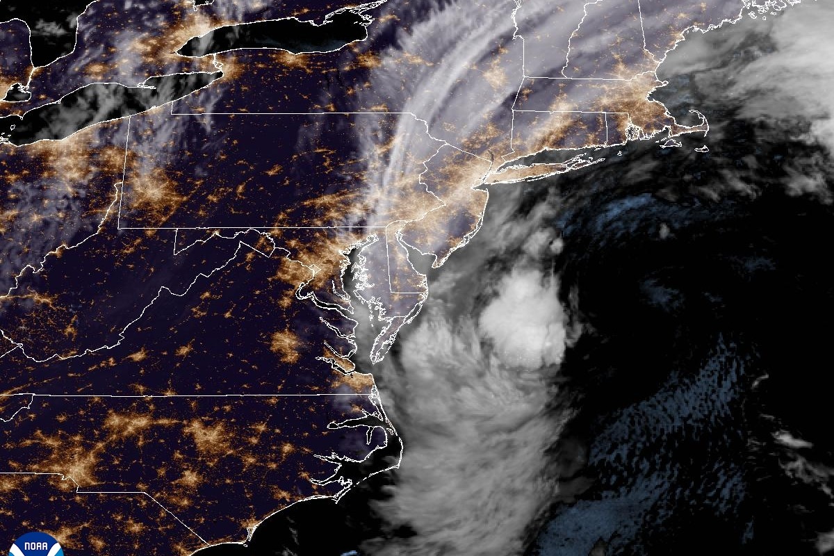
An early season nor’easter is spinning up off Cape Hatteras and will spread strong wind, coastal flooding and rain from the Outer Banks to Cape Cod through the weekend, according to National Weather Service forecast discussions issued late Friday. As of late Friday, the storm’s low pressure center sat about 200 to 250 miles off Cape Hatteras and was expected to strengthen as it tracks up the coast, per the Weather Service office in New York. Governors in New Jersey and New York have both declared states of emergency ahead of the weekend.
New Jersey and Delaware
The National Weather Service’s Mount Holly office had a High Wind Warning in effect for the Jersey Shore and Delaware beaches until 6 a.m. Sunday, calling for “North winds 30 to 40 mph with gusts up to 60 mph” and saying “widespread power outages are expected.” The office also raised its coastal flood forecast to Major Coastal Flood levels for the New Jersey Atlantic coast, the Delaware Atlantic coast and parts of Delaware Bay, expected “around the time of high tide Saturday morning,” worsened by Saturday’s full moon. Surf of 6 to 12 feet is expected in the zone through Sunday, with beach erosion and possible dune breaching. Rainfall is forecast at 2 to 4 inches along the I-95 corridor and 3 to 5 inches over much of eastern New Jersey.
New York City and Long Island
The Weather Service office in New York has a Coastal Flood Warning in effect for Brooklyn, southern Queens and other low-lying areas until 6 p.m. Sunday, with 2 to 3 feet of inundation possible in vulnerable areas — inundation meaning water above normally dry ground. The warning identified Jamaica Bay as the primary concern and named southern Nassau and southwest Suffolk as facing the greatest threat of major flooding. Wind gusts of 40 to 50 mph are expected, locally near 55 mph on the south shore and east end of Long Island. Forecasters, in a 9:32 p.m. Friday update, forecast 4 to 6 inches of rain for Long Island and New York City and 1.5 to 3.5 inches elsewhere. The Weather Prediction Center has placed Long Island and New York City in a Slight Risk (2 of 4) for excessive rainfall. Tidal flooding is also expected along the Hudson River, with a Flood Advisory for Westchester, Rockland, Orange and Putnam counties and a Flood Warning at Poughkeepsie on Saturday. For Long Island and Queens, forecasters said guidance shows Saturday morning’s high tide as the highest, with water levels having “trouble falling too much” with the Saturday evening and Sunday morning tides.
Southern New England
Boston forecasters have a High Wind Warning in effect for the eastern Massachusetts coast, the south coasts of Rhode Island and Massachusetts, and Cape Cod and the Islands until 8 a.m. Sunday, calling for “Northeast winds 20 to 30 mph with gusts of 50 to 60 mph.” Forecasters said “a few gusts of 65-70 mph” are “not out of the question towards Block Island,” with inland gusts of 35 to 50 mph. They wrote that “the wind and tree damage/power outage risk will be the biggest impact for most people,” a risk compounded by trees still in full leaf. Storm surge of 1 to 2 feet, briefly near 2.5 feet, is expected along east-facing beaches, with offshore seas of 15 to 25 feet and “severe beach erosion.” A Coastal Flood Warning covers the eastern Massachusetts coast, Cape and Islands until 8 p.m. Sunday. Rainfall of 2 to 4 inches is expected, with localized totals of 5 to 6 inches. Because the storm will affect multiple high-tide cycles, forecasters said the water “may struggle to drain out after each high tide.”
Virginia and the Outer Banks
A Coastal Flood Warning is in effect for Hampton Roads — Chesapeake, Suffolk, Hampton, Poquoson, Norfolk and Portsmouth — until 1 a.m. Sunday, with 2 to 3 feet of inundation forecast, “sufficient depth to close numerous roads and threaten homes and businesses”; the peak there is expected Saturday night into early Sunday. A Wind Advisory covers the Eastern Shore and Maryland beaches, with gusts of 45 to 50 mph, until 11 a.m. Saturday. Farther south, a Coastal Flood Warning covers Hatteras Island until 11 a.m. Saturday, with 2 to 4 feet of inundation possible and surf of 8 to 12 feet north of Cape Hatteras; overwash is again likely around Saturday’s roughly 7:30 a.m. high tide.
When the worst tides come
The storm’s coastal flooding tracks the high-tide cycle. NOAA’s predicted astronomical high tides (local time, before any storm surge is added) are: at the Battery in New York, 8:23 a.m. and 8:39 p.m. Saturday; at Atlantic City, New Jersey, 7:41 a.m. and 8:00 p.m. Saturday; at Sewells Point near Norfolk, Virginia, 9:23 a.m. and 9:41 p.m. Saturday; and in Boston, 11:34 a.m. and 11:54 p.m. Saturday. The next high tides come Sunday morning — around midday in Boston.
Emergency declarations
New Jersey Gov. Mikie Sherrill signed Executive Order No. 25 on Friday, declaring a state of emergency effective 5 p.m. for Atlantic, Burlington, Cape May, Cumberland, Middlesex, Monmouth, Ocean and Salem counties and activating the State Emergency Operations Center. New York Gov. Kathy Hochul likewise declared a state of emergency for the Bronx, Kings, Nassau, New York, Queens, Richmond, Suffolk and Westchester counties, saying, “Take this storm seriously. Stay alert, and avoid unnecessary travel.” New York has 5,675 workers available statewide for response, restoration and repairs, including 175 Con Edison mutual-aid contractors, and has pre-staged swift-water rescue teams; New Yorkers can text their county or borough name to 333111 for alerts.
What is still uncertain
As of late Friday, forecasters had not confirmed where — or whether — the storm’s center will come ashore. The Weather Service office in New York said that Saturday night into Sunday the low “will retrograde toward the coast, possibly coming onshore around the Jersey Coast (though there still remains some uncertainty with this),” before weakening, possibly stalling nearby through Monday, and departing to the northeast on Tuesday. Mount Holly forecasters put it more starkly, writing that the trend in recent model runs has “been to bring the storm closer to the shore, and even have the center of the Nor’easter move into New Jersey Saturday night.” Rain is expected to end from southwest to northeast Monday into Monday night, with North Carolina clearing first and Boston seeing rain and gusty wind linger into Monday.
Sources and further reading
- Area Forecast Discussion, NWS New York (9:32 p.m. EDT Sept. 25, 2026)
- Area Forecast Discussion, NWS Mount Holly (9:01 p.m. EDT Sept. 25, 2026)
- Area Forecast Discussion, NWS Boston (7:37 p.m. EDT Sept. 25, 2026)
- NOAA Tide Predictions (The Battery, Atlantic City, Sewells Point, Boston)
- Governor Sherrill Declares State of Emergency Across Eight Counties in Preparation for Nor’easter
- Governor Hochul Declares State of Emergency as Coastal Storm Hits New York