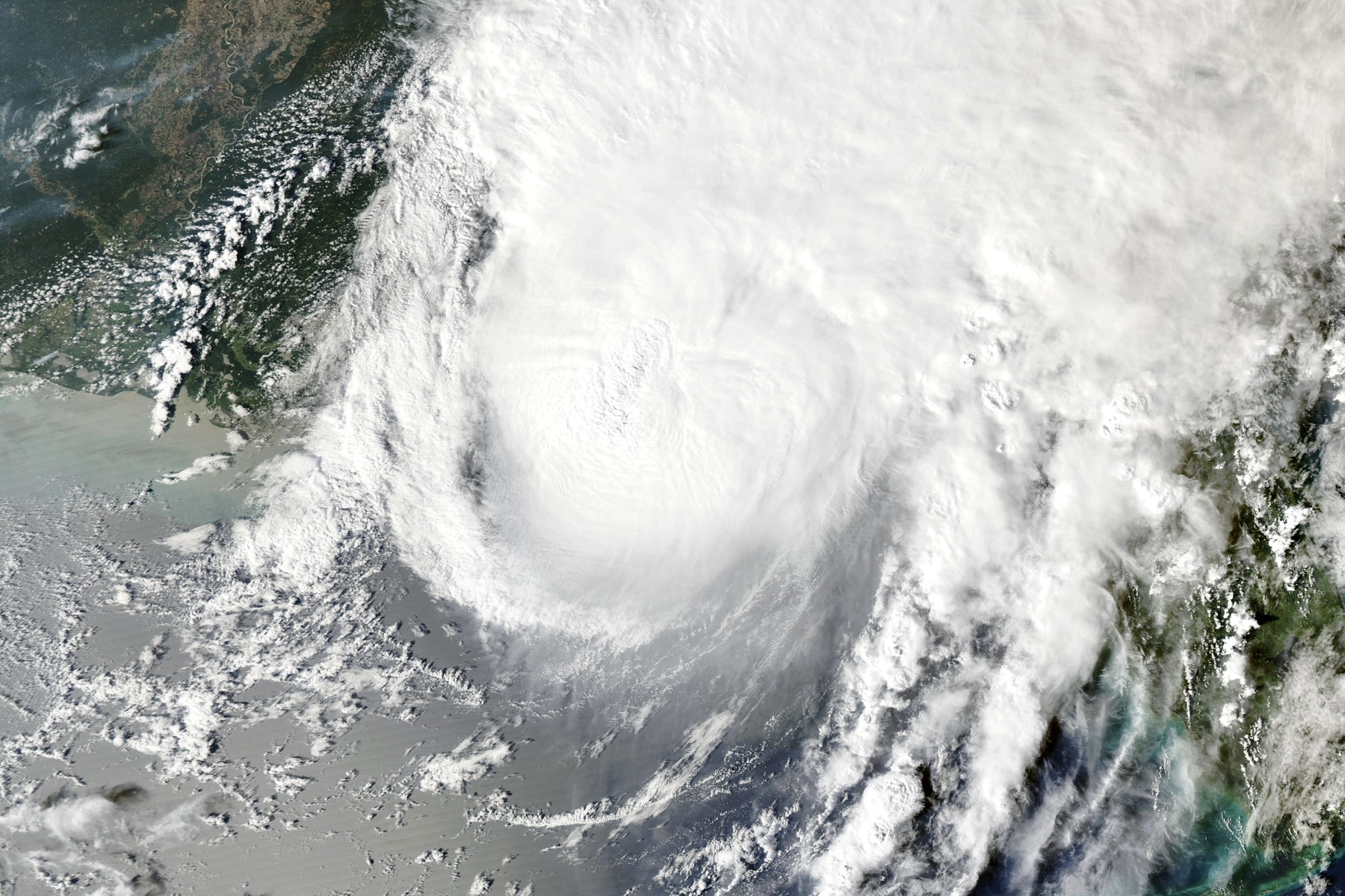
Update, Oct. 13, 2026: This is Plainly Now’s main page on Isaias; it folds in the forecast pages Plainly Now published on Oct. 7 and Oct. 8. The National Hurricane Center’s advisory record shows how the storm developed: it formed as Tropical Depression Nine in the Gulf on Tuesday, Oct. 6, became Tropical Storm Isaias early Wednesday, Oct. 7, and became a hurricane early Thursday, Oct. 8. It peaked at 120 mph (Category 3) with a central pressure of 959 millibars on Friday morning, Oct. 9 (Advisory 12), weakened slightly before landfall, and was a post-tropical cyclone by 1 a.m. CDT Saturday, Oct. 10. The Weather Prediction Center’s last advisory in the record, Number 20 at 11 a.m. EDT Sunday, Oct. 11, put the remnant low at 25 mph over Kentucky and said the flash-flood threat was decreasing. The sections below are the account written on Saturday, Oct. 10.
Isaias, which made landfall near Destin, Florida, as a hurricane Friday night, has been blamed for at least four deaths as of about 5:30 p.m. EDT Saturday, Oct. 10, 2026. It has since weakened to a post-tropical cyclone, a storm that is no longer classed as tropical but can still bring damaging wind and heavy rain, and flash flooding, tornadoes and landslides remain a threat as it moves through Alabama and the Southeast. Where a time is known, it is given next to the number. Isaias is the first U.S. hurricane landfall since Milton, according to CNN, which wrote that Milton came ashore as a Category 3 south of Tampa “exactly two years ago,” in October 2024.
What happened
An advisory is the National Hurricane Center’s numbered public update; a discussion is the forecasters’ written reasoning that accompanies each advisory. The National Hurricane Center (NHC) rated Isaias a Category 3 hurricane in its Friday advisories: Advisory 12, issued at 11 a.m. EDT (10 a.m. CDT), put maximum sustained winds near 120 mph with a central pressure of 959 millibars (lower pressure means a stronger storm), about 195 miles south of Pensacola. By Advisory 13, at 5 p.m. EDT (4 p.m. CDT), winds were near 115 mph, and the advisory expected little change in strength before landfall.
The storm came ashore weaker than the Category 3 that the models and Advisory 13 pointed to. In Discussion 13, the NHC said forecast models indicated Isaias was “likely to be at or near major hurricane strength at landfall.” The NHC said Isaias made landfall near Destin at 9:30 p.m. EDT (8:30 p.m. CDT) Friday as a hurricane with 90-knot sustained winds, about 104 mph by conversion. NBC, citing the NHC, and Fox10 report 105 mph; NBC, CBS, CNN and Fox10 all say Category 2. One CBS entry puts landfall at “around 8 p.m. Eastern Time”; the NHC’s own time is 9:30 p.m. EDT.
The NHC’s Advisory 15, issued at 5 a.m. EDT (4 a.m. CDT) Saturday, was titled “Post-Tropical Cyclone Isaias.” It put winds at 35 mph, with the storm’s center about 25 miles south-southwest of Montgomery, Alabama. It was also the NHC’s last advisory. The Weather Prediction Center (WPC) has issued them since Advisory 16 at 11 a.m. EDT (10 a.m. CDT).
What “post-tropical” means, and why a weakened storm still kills
In Discussion 15, the NHC wrote that “all deep convection has been scoured well northward away from the low-level center,” with a warm front extending eastward from the former tropical cyclone. Deep convection means the tall thunderstorm clouds that power a hurricane. The NHC said Isaias had transitioned into a post-tropical cyclone, so Advisory 15 was its last and the WPC took over. That transition came earlier than forecast: Discussion 13, written Friday afternoon, had expected it over Alabama by Saturday afternoon, and Discussion 15 showed it done by 4 a.m. CDT Saturday.
Losing the label does not remove the danger. In Discussion 14, the NHC wrote: “Although the sustained surface winds associated with Isaias will quickly weaken now that the storm is inland, damaging wind gusts associated with the system are expected to extend well inland through Saturday, especially in areas of higher terrain.” Discussion 15 added that “there is still a risk of some high wind gusts over the southern Appalachians” along with “the potential for heavy rain causing flash floods.” The NHC’s Robbie Berg told the Associated Press: “So even though it has become post-tropical, it still does remain a wind threat, as well as a heavy rainfall threat. We could see some areas of significant flash flooding over the next couple of days.”
Of the four deaths reported, the circumstances given were falling trees (two), a generator in a closed garage (one) and, per later reporting by the Associated Press, a wreck involving fallen trees (one).
Two kinds of flooding are in play. Storm surge is the sea water the storm pushes ashore. DeSantis’s figure of water about 5.5 feet above normal (NBC, 9:15 a.m. EDT) describes that coastal water, and it is his figure, not an NHC measurement. Advisory 15 said at 5 a.m. EDT: “Water levels will continue to recede along the Florida Gulf Coast throughout the day.” Inland flooding from rain and rivers is the part still building, as the sections below show.
Where it is now
Advisory 17, issued by the WPC at 5 p.m. EDT (4 p.m. CDT) Saturday, put the storm’s center about 5 miles west of Birmingham, Alabama. Maximum sustained winds were near 30 mph and the central pressure was 1007 millibars. The system was moving north-northeast at 15 mph. The advisory says that motion is “expected to become more northeasterly and accelerate by Sunday.” The forecast table in the WPC discussion that goes with it shows the system dissipating by about 2 a.m. EDT Monday, Oct. 12; an earlier forecast table (Discussion 16) had placed that later, at 8 a.m. EDT Monday. The next complete advisory is due at 11 p.m. EDT (10 p.m. CDT) Saturday.
The four deaths, one by one
Death counts come from county and state officials, as relayed by CBS (4:51 p.m. EDT), NBC (4:53 p.m.) and CNN (5:25 p.m.), which each report at least four, two in Florida and two in Alabama. The NHC advisories do not give a death toll. One report, from Fox10 at 4:13 p.m., still said three.
- A tree on a home in Escambia County, Florida. According to the Escambia County Sheriff’s Office, as quoted by NBC, Fire Rescue found a person “pinned under a large tree” inside a home in the Pensacola area on Friday evening. Gov. Ron DeSantis confirmed the death at an afternoon news conference Saturday.
- A closed garage in Escambia County. The sheriff’s office told CBS (2:48 p.m.) that deputies went to Wilderness Lane on Saturday and found a person dead in a closed garage with a running generator inside. A sheriff’s office spokesperson called the death “weather-related to Hurricane Isaias” (NBC, 2:03 p.m.). The Associated Press later reported that Sheriff Chip Simmons said the person died of carbon monoxide fumes from the generator. Four family members, ages 72, 24, 5 and 4, were taken to a hospital for non-life-threatening treatment, the sheriff’s office said (CBS, 2:48 p.m., and CNN). Fox Weather reported that they were being treated for carbon monoxide poisoning. At the same news conference DeSantis warned residents, “Don’t run the generator inside … It’s something that can be fatal” (NBC, 2:56 p.m.).
- A tree on a house in Jefferson County, Alabama. According to the Jefferson County Emergency Management Agency (CBS, 11:01 a.m.), a person was killed in the Huffman area of Birmingham when a tree fell on a house. Birmingham Fire and Rescue Capt. Orlando Reynolds told CNN that two people were trapped. The county emergency management agency said it was “not aware of any additional storm-related injuries” (CNN; NBC, 10:01 a.m., quoting agency officer Shea Hess). Later reporting by the Associated Press quoted Birmingham Fire Chief Cory Moon as saying one person was treated at the scene and the other was pronounced dead; other outlets did not give the second person’s condition.
- Barbour County, Alabama. Gov. Kay Ivey’s office confirmed a death in Barbour County and gave no circumstances (CBS, 2:55 p.m.). Fox10 reported that the Alabama Emergency Management Agency also confirmed it. The agency later said, as the Associated Press and local outlets reported, that a driver died after a wreck involving fallen trees and was taken to a medical facility in Dale County, where the person died.
Ivey’s statement said two Alabamians had died; in her words, “we have also learned that two Alabamians have lost their lives.” CBS tied those two to the Jefferson County and Barbour County deaths.
Damage and what officials said about it
Reports so far are scattered, not a full survey. Pensacola Mayor D.C. Reeves said on Facebook, as the Associated Press and CBS reported (10:00 a.m. EDT), that the city’s airport “took some damage.” NBC describes a stripped hotel roof in Pensacola. FOX10 describes a stripped convenience-store roof in East Milton and NBC one in Milton, and an Associated Press photo caption describes a torn-off apartment roof there. A family in Gulf Breeze hid under a mattress minutes before the storm tore off part of their roof, according to NBC, CBS and CNN; NBC (4:53 p.m.) said they were unhurt. In Dale County, Alabama, a sheriff’s deputy was pinned by a tree and treated for minor injuries, NBC reported at 11:01 a.m.
DeSantis said, “I think our structures handled the storm very well. The problem is that the storm knocked over a lot of trees.” He also described wind gusts of up to 116 mph near Santa Rosa Sound (NBC, 9:15 a.m. EDT). That is the governor’s figure. The NHC’s 10 p.m. EDT Friday update reported that a NOAA National Ocean Service station at Panama City Beach recorded a gust to 83 mph and a sustained wind of 72 mph. Okaloosa County Sheriff Eric Aden said, “It could have been a lot worse … Given the significant strength of the storm, I consider ourselves lucky.” Gulf Shores Mayor Robert Craft told CNN it was “a scary night” and that “it could have been much worse.”
The Weather Prediction Center’s Storm Summary Number 2 (11 a.m. EDT Saturday) lists preliminary rainfall from 8 a.m. EDT Friday to 10 a.m. EDT Saturday of 12.97 inches at Bellwood, Alabama, 12.47 inches at Caney Creek and 12.43 inches at DeFuniak Springs, Florida, and 7.52 inches at Destin. Its preliminary peak gusts included 117 mph at Oriole Beach, 114 mph at Milton and 105 mph at Navarre, Florida, some of them from Texas Tech University StickNet instruments, and 92 mph at Pensacola International Airport.
Power outages
Outage counts move by the hour. At 7:38 a.m. EDT Saturday, PowerOutage.us, as cited by CBS, showed more than 884,000 customers without power. At 2:21 p.m., CBS showed more than 700,000 across the region: 422,357 in Florida, 200,930 in Alabama, 44,877 in Georgia, 18,824 in Mississippi and smaller numbers in the Carolinas and Tennessee.
DeSantis said about 10,000 outages had been restored and more than 430,000 customers in Florida remained without power, NBC reported at 2:56 p.m., a little above the tracker’s Florida count from about the same hour. An Alabama Power delivery engineer, Meredith Morgan, told CNN, in an interview whose time was not given, that more than 275,000 customers in Alabama lost power and over half had been restored. NBC’s 4:53 p.m. summary says nearly 700,000 customers were without power; CBS’s summary, updated 4:51 p.m., says more than 600,000. Neither gives the time of its count, and the lower figure may simply be a later one.
Emergency declarations
A federal emergency declaration lets the federal government help a state; a state of emergency is the governor’s own order. CBS reported at 5:23 a.m. EDT Saturday that President Donald Trump approved emergency declarations for Florida and Alabama on Friday night, and later reported one for Georgia on Saturday. DeSantis declared a state of emergency covering more than two dozen Florida counties, and Ivey did so for 40 Alabama counties. Georgia Gov. Brian Kemp also declared a state of emergency.
What comes next
The main rain and wind threat has moved inland and north, but river flooding in the western Panhandle continues. Advisory 17 (5 p.m. EDT) says “3 to 6 inches with localized maximum amounts of 10 inches” of rain are possible across the Southern Appalachians, from northeast Georgia into the western Carolinas, and from the upper South Carolina coast into eastern North Carolina. Another 1 to 2 inches are possible across the rest of the Southeast into northern Florida. It warns of flash, urban and river flooding, with “considerable impacts, including landslides” possible in the southern Appalachians. It lists flood watches for parts of the Southeast and the Southern Appalachians and a High Wind Warning for parts of the southern Appalachians.
Three other hazards remain:
- Rivers: “Significant river flooding across the western Florida Panhandle will crest today through Sunday.” A river crests when it reaches its highest level. The NHC, WPC and CNN material cited here gives no crest height. CNN reported that the Shoal River in Okaloosa County was not forecast to crest for another few days, according to Jared Perdue of the Florida Division of Emergency Management, and that several rivers were expected to reach “moderate” or “major” flood stage, though record crests were not anticipated, according to NOAA river gauges.
- Tornadoes: “A couple of tornadoes are possible today across eastern Georgia and the Carolinas.” Fox Weather reported a confirmed tornado near Appleton, South Carolina, at 4:27 p.m. EDT, citing the National Weather Service in Charleston. As of 5 p.m. EDT, no casualties from that tornado had been reported.
- Surf and wind: Swells are likely to cause “life-threatening surf and rip current conditions” on Gulf coasts this weekend. Strong gusts are a threat near the Southern Appalachians, with scattered power outages and downed trees possible.
The NHC’s key message on post-storm safety says: “Ensure generators are properly ventilated and placed outside at least 20 feet away from dwellings and garages to avoid carbon monoxide poisoning.”
Forecast versus outcome, and what is still unknown
Two things differ from the forecasts. In Discussion 13, written Friday afternoon, the NHC said the forecast models had “honed in on a landfall over the western Florida Panhandle near the Pensacola area.” Landfall was near Destin, to the east. And where the models cited in Discussion 13, and Advisory 13’s outlook of little change in strength, pointed to Category 3 at landfall, the NHC put landfall intensity at 90 knots, about a Category 2, after Category 3 winds earlier in the day.
Several things are not known yet:
- Birmingham accounts differ on the second trapped person: the Associated Press quoted the fire chief on that person’s condition, while other outlets gave none.
- Crest heights for the Florida rivers are in National Weather Service river forecasts, which were not among the reporting used here.
- The NHC’s Tropical Cyclone Report, its final written review of the storm, which can revise the landfall intensity, has not been issued.
- National Weather Service damage surveys and tornado ratings were not among the reporting used here, and the coastal surge figure above is the governor’s.
- The death count is still moving. DeSantis said, “There tends to be injuries and, unfortunately, deaths in the days after.”